Student-led publication reveals that diverging socioeconomic conditions and regional land use change decisions could dramatically decrease or increase future agriculture-driven habitat loss.
The impact of land use changes on native habitat
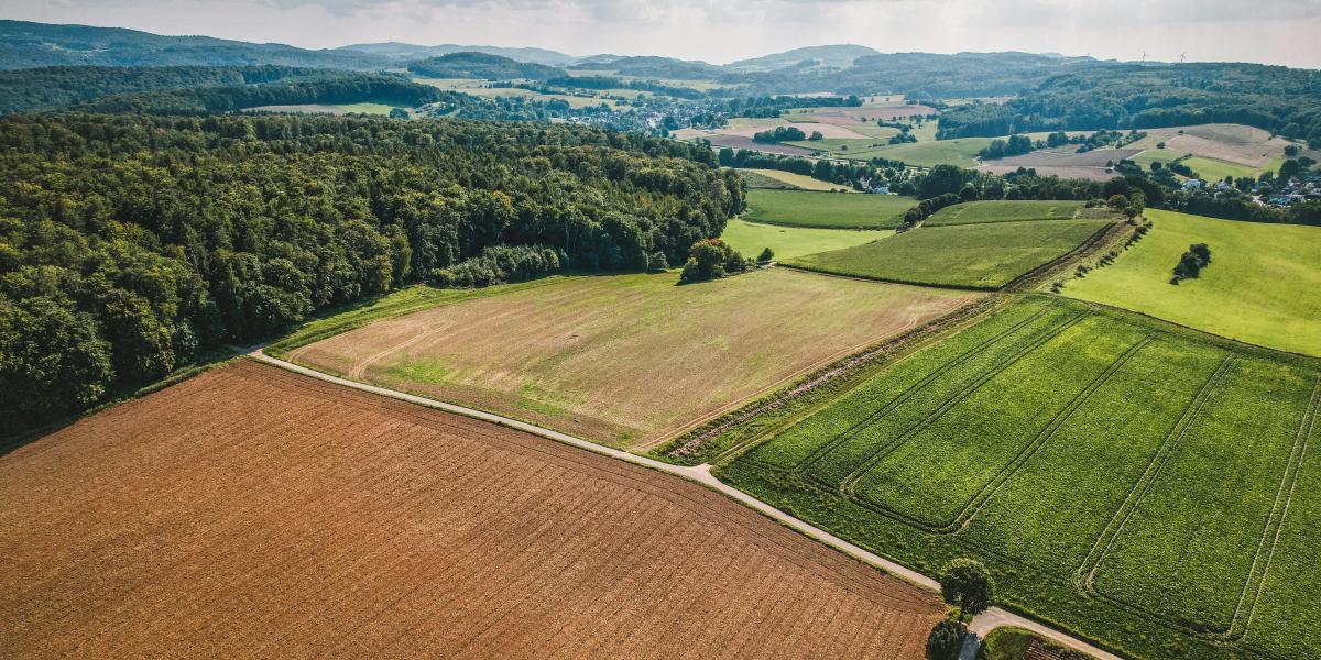
From burning forests to planting crops, humans have altered their natural habitat for millennia. But agriculture in particular has played a major role in land use changes globally.
Today, agriculture covers over a third of Earth’s land area and significantly affects the surrounding natural habitat. Over the next few decades, three major forces – population growth, climate change, and land use policies –are expected to drive major changes to how agricultural land is used and how it impacts the environment. Population growth will control how much agricultural land is needed, climate change will influence where certain crops can be grown, and land use policies will govern where agricultural land will replace natural habitat.
When natural ecosystems are converted to agricultural land, the total available area for native habitat decreases, and remaining habitat areas become more fragmented. Habitat loss and fragmentation lead to smaller, isolated wildlife populations with less diversity and resilience, contributing to global biodiversity loss. These landscapes are less able to support the species that rely on them, and more vulnerable to further degradation.
However, the opposite change can also occur; agricultural areas can be abandoned and left to revegetate into partially or fully native habitat, improving the connectivity of separate habitat patches over a period of many years. In some cases, abandoned agricultural areas can be re-cultivated and used for farming again. Recultivating abandoned agriculture could prevent natural ecosystems elsewhere from being converted to agriculture.
In the United States, 25.8 to 34.6% of cropland has been abandoned since 1850, and more abandonment is expected in the coming decades. Whether this abandoned agriculture will be revegetated or re-cultivated, and where these changes will occur in the future, will affect habitat quality, biodiversity, and carbon sequestration. Leveraging the location of agricultural land use change could prevent biodiversity and carbon hotspots from being converted to agriculture and allow abandoned land to revegetate and reconnect fragmented habitat areas.
However, the fate of agricultural abandonment is uncertain. It is still unclear whether global socioeconomic forces like trade and population growth will have more of an influence than regional decisions in shaping these land use outcomes.
Understanding land use changes under climate change with SPARCLE
To better understand this issue, we collaborated with Conservation International (CI) as Arnhold Fellows to quantify how agricultural land use may change in the future and how those changes might affect the nearby habitat. Specifically, we assessed where and how potential land use changes might affect landscape fragmentation and connectivity while conserving environmentally important land.
“I was excited about this project because I’m passionate about agriculture’s potential to address climate change and ecological conservation, all while feeding a growing global population. This project is interesting because agriculture abandonment is a prominent land use change trend, so understanding how global driving forces and regional decisions will affect abandonment is crucial for predicting agriculture’s effect on the environment. The opportunity to work on this project with Conservation International was incredibly rewarding. As an Arnhold Fellow at emLab, I was able to collaborate with experts while learning essential research skills like geospatial analysis, coding, and scientific communication.” - Alyssa Jain, lead author and Arnhold Undergraduate Fellow (2021 - 2023)
This effort is part of a larger body of work at emLab called SPARCLE (Spatial planning for climate change: Land use for conservation, agriculture, and energy), led by Ashley Larsen (emLab), Patrick Roehrdanz (CI), and Cameryn Brock (CI). SPARCLE helps decision-makers navigate these trade-offs and identify land-use strategies that benefit both biodiversity and people. Thanks to a close partnership with CI, supported by the John and Jody Arnhold Climate Solutions Collaborative, we were able to model revegetation and recultivation of agricultural abandonment under four different socioeconomic scenarios.
Modeling changes in agricultural land use in the United States
Our research, now published in Environmental Research Letters, focused on the southeastern United States, since it has historically been a hotspot of agricultural land use change. The region also hosts high biodiversity and important carbon sinks, making it a priority for biodiversity conservation and climate change mitigation. To assess how future land use changes could affect this high-priority region, we used the USGS Forecasting Scenarios of Land Use Change dataset, which provides annual future land use maps for four socioeconomic scenarios (global economic, local economic, global environmental, and local environmental).
The socioeconomic scenarios are guided by 2100 targets for global gross domestic product (GDP) and global population. They further differ in two main dimensions: they are oriented towards either economic development or environmental concern, and towards either global or regional development patterns. Economic scenarios predict rapid economic growth, while environmental scenarios predict greater environmental and social consciousness. Global scenarios predict converging global living standards, while local scenarios predict regional development and identities.
In each of these scenarios, the dataset models future land use. For example, in the global economic scenario, high GDP and increased global living standards drive higher demand for biofuels and food production, at the expense of natural land (Figure 1a). In contrast, the global environmental scenario predicts moderate GDP and conservation of natural land, which results in less agricultural land and more natural land (Figure 1a).
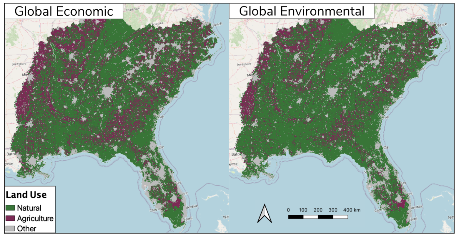
Figure 1a. Land use maps for the global scenarios, projected for 2050. The global economic map on the left has more purple (agriculture) and less green (natural) than the global environmental map on the right. This illustrates how the different socioeconomic conditions that characterize each scenario drive varying land use trends.
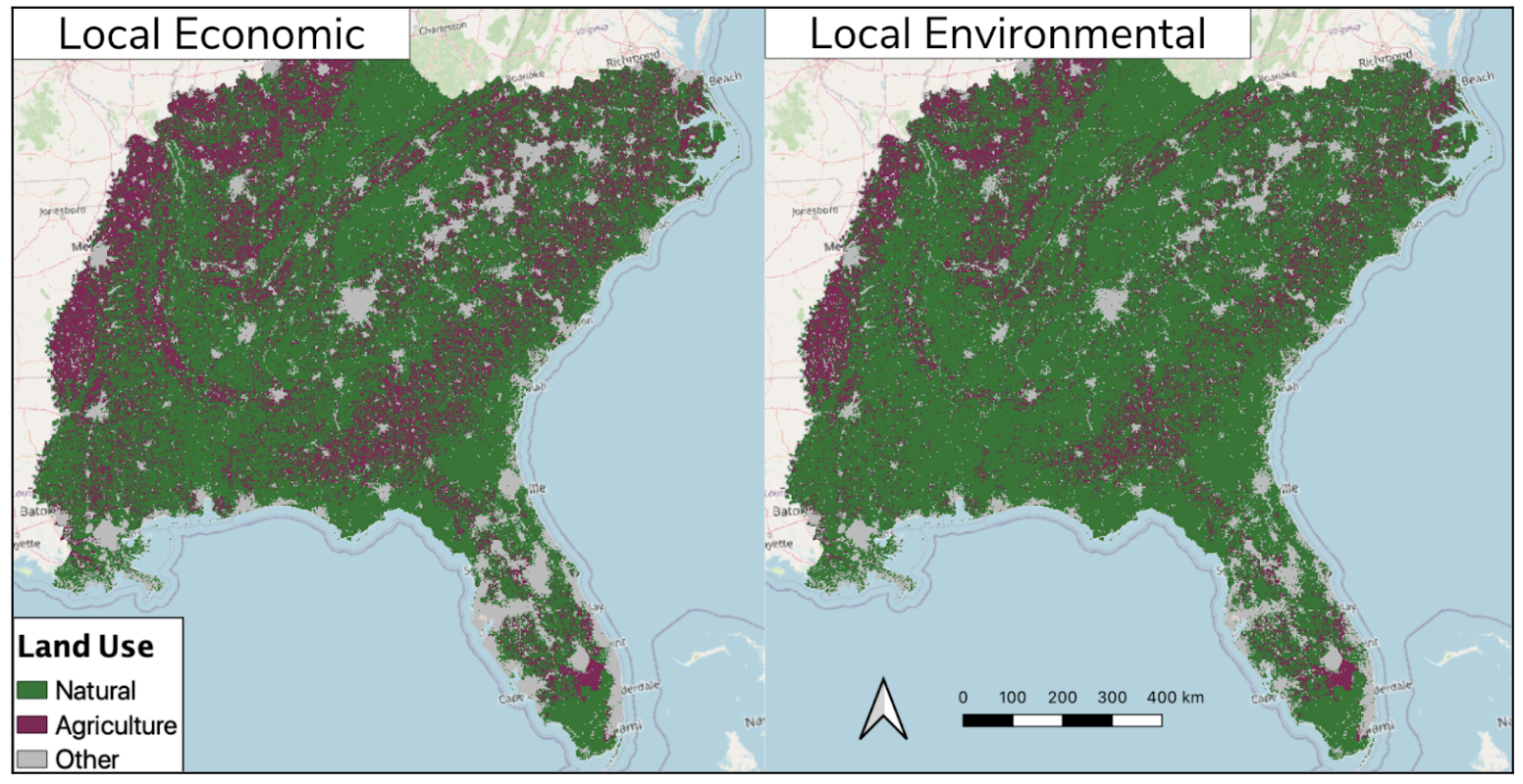
Figure 1b. Land use maps for the local scenarios, projected for 2050. The local economic map on the left has more purple (agriculture) and less green (natural) than the local environmental map on the right. This illustrates how the different socioeconomic conditions that characterize each scenario drive varying land use trends.
In the local economic scenario, faster population growth increases agricultural land as the demand for food grows (Figure 1b). However, in the local environmental scenario, conservation of natural land is prioritized, and less agricultural land is needed to feed a smaller population (Figure 1b).
For each socioeconomic scenario, we evaluated which strategy for abandoned agriculture reduced habitat fragmentation the most:
- Revegetation – passively allowing land to regrow into natural ecosystems over the course of several decades
- Random recultivation – selecting abandoned agricultural areas at random to use for farming again
- Strategic recultivation – selecting only abandoned agricultural areas with the least biodiversity and carbon content to use for farming again. This strategy preserves natural ecosystems with high biodiversity and carbon content by preventing them from being used for farming again.
Our team then evaluated connectivity, or how easily wildlife can move across a landscape. Connectivity is important for sustaining healthy wildlife populations by allowing species movement to access resources, maintain genetic diversity, and respond to environmental changes. Patches of agricultural land that fragment natural spaces can lower connectivity. The amount and location of agricultural land within a natural landscape is particularly relevant for large predators, since they typically need greater areas of unfragmented habitat.
With this in mind, we selected the American Black Bear as a representative species to assess connectivity. American Black Bears are an ideal species to use because they can travel long distances, so habitat connectivity can meaningfully affect their movement. Further, they need large habitat areas and their range overlaps with many rare bird, reptile, amphibian, and plant species, conserving areas for bears would also support habitat for other species.
What agricultural land use change means for conservation and climate
Our study revealed that environmental scenarios led to much more agricultural abandonment than economic scenarios. Further, environmental scenarios had much less natural habitat loss due to agricultural conversion (Figure 2). As a result, environmental scenarios projected significantly less habitat fragmentation, and greater connectivity between key habitat areas for American Black Bears.
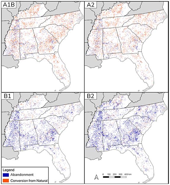
Figure 2: Distribution of abandonment and conversion in the southeastern United States from 1990 to 2050. The economically oriented A family scenarios experience greater conversion from natural land to agriculture, while the environmentally oriented B family scenarios experience greater abandonment from agriculture to natural land.
Socioeconomic factors – economic growth, global population and environmental policy – are the primary drivers of future agricultural land use change and the resulting effects on habitat. Still, under the same socioeconomic conditions, strategic recultivation targeting carbon or biodiversity conservation can reduce habitat fragmentation by up to 17% compared to revegetation and random recultivation.
Findings from this study suggest that the most impactful way to influence habitat availability, fragmentation, and connectivity is through economic growth, global demographics and environmental policy. However, strategic agricultural recultivation successfully reduced some fragmentation while critically protecting carbon sinks and high biodiversity habitats. By considering these ecosystem services when making regional decisions about where to recultivate or expand agricultural land, land use planners can increase environmental benefits.
Looking forward, emLab and CI are continuing to research climate smart land-use planning under scenarios of future change under SPARCLE, including the future of human-elephant conflict in central Africa, and the role of multifunctional landscapes in achieving multiple sustainable development goals.


Agricultural land abandonment presents potential environmental benefits through either revegetation, and associated carbon sequestration, habitat and landscape connectivity benefits, or recultivation, which offsets the need for agricultural conversion of natural areas. Yet, the extent and pace of land abandonment depends on future demand for food, energy, and other anthropogenic drivers. Here we quantify the extent and spatial distribution of agricultural abandonment and conversion in the southeastern US under a range of future development scenarios, addressing (1) what is the extent of future agricultural abandonment and conversion, (2) how much forecast agricultural conversion could be offset by recultivation of abandoned land, and (3) within a given development scenario, how do different strategies for recultivation of abandoned lands influence (a) habitat fragmentation and (b) connectivity for the umbrella species Ursus americanus. Future abandonment ranged from 1.63 Mha (local economic scenario) to 7.95 Mha (local environmental scenario). Future conversion ranged from 1.24 Mha (global environmental scenario) to 5.65 Mha (global economic scenario). While environmental scenarios predicted surplus abandonment available to offset all conversion, economic scenarios predicted enough abandonment to offset a third of conversion at most. Within a given development scenario, strategic recultivation targeting carbon or biodiversity conservation can reduce fragmentation by up to 17% compared to land-use decisions that do not consider those characteristics. However, strategic recultivation did not significantly affect connectivity, which was instead driven by development scenarios: cost-weighted distance to least-cost path ratio was highest in the economic development scenarios and lowest in the environmental concern scenarios. Our results suggest that while socio-economic development scenarios are the primary drivers of land-use change patterns and the attendant ecological consequences, strategic recultivation decisions targeting carbon sequestration or biodiversity potential can reduce habitat fragmentation within development scenarios.


