Home to pristine reefs, thriving marine life, and cultural seascapes, the Pacific Remote Islands (PRI) Marine National Monument provides protection across five discontiguous areas in the central Pacific. The Monument currently covers 1,275,000 km2 and protects the islands and waters surrounding Wake Atoll, Johnston Atoll, Jarvis Island, Kingman Reef/Palmyra Atoll, and Howland Island/Baker Island. The region is a haven for numerous threatened and endangered species (e.g. giant clams, humphead wrasse, green sea turtles) and supports some of the highest levels of coral diversity in the central Pacific.
On March 24th, 2023, President Biden announced an intention to further protect this area, issuing a Memorandum on Conserving the Natural and Cultural Heritage of the Pacific Remote Islands that directs the Secretary of Commerce to consider initiating the designation process for a proposed national marine sanctuary in the Pacific Remote Islands area. On April 17th, 2023, NOAA’s Office of National Marine Sanctuaries initiated the designation process and began scoping for the potential new sanctuary. The sanctuary designation would supplement and not change the existing protections of the monument. The designation as nominated by the PRI Coalition would extend protections to the United States Exclusive Economic Zone (EEZ) border of Howland Island/Baker Island and Kingman Reef/Palmyra Atoll (called “the expansion area” herein).
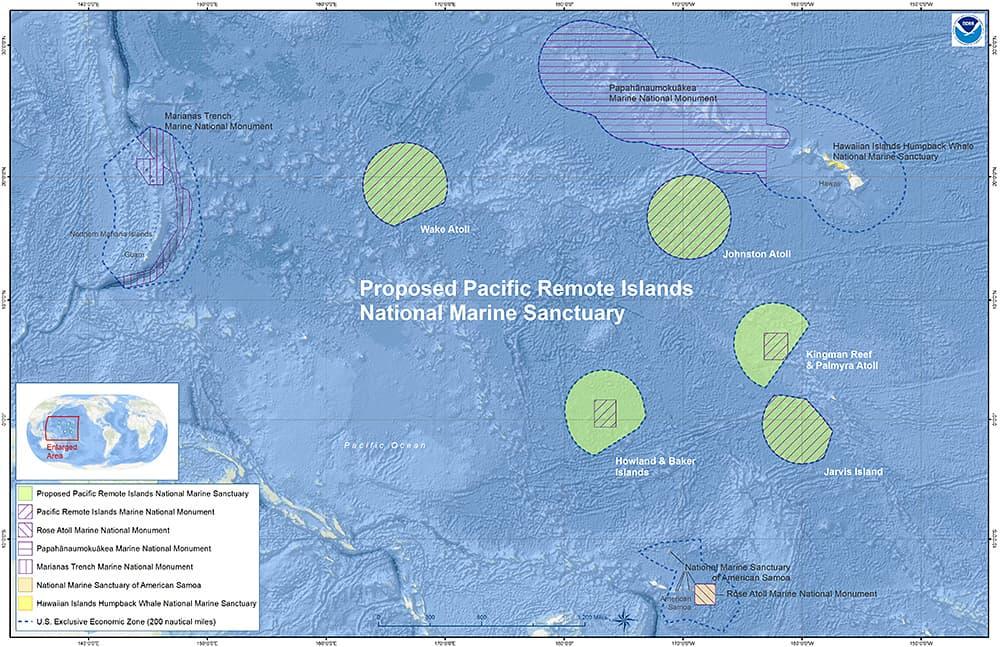
Proposed Pacific Remote Islands National Marine Sanctuary. Credit: NOAA.
The newly designated National Marine Sanctuary would provide 686,000 km2 of additional protection around the Pacific Remote Islands. Expansions have raised concerns among some in the past about how regional fisheries and fishery-dependent industries may be impacted by new protections. One of the main concerns for expanding PRI now is the potential impact that the sanctuary may have on the tuna cannery in Pago Pago, American Samoa, which is one of the U.S.’s largest tuna canneries and provides jobs and revenue to the local community.
To better understand the potential impact of the sanctuary on the cannery and fisheries in the region, central questions to address include: how much fishing effort occurred in the expansion area historically? Where are U.S. fleets fishing across the Pacific? Where does catch landed in Pago Pago originate from?
With the proliferation of remotely sensed data, emLab is able to objectively examine historical fishing effort data in the region to answer these questions, ultimately providing better information for decision and policy makers on the potential economic impacts of these expansions. Given that additional protections within the U.S. EEZ would affect the U.S. fishing fleet, we focus our analysis on U.S. flagged vessels and two main gear types used to catch tuna in the region: purse seine and longline.
Historically, there have been relatively low levels of fishing effort inside the expansion area by U.S. vessels. While looking at historical fishing activity does not provide a causal impact assessment of what would happen in the future if this new Sanctuary is designated, it provides an objective baseline for better informed conversations about what could happen. Our analysis found that the U.S. purse seine fleet spent 0.52% of their effort fishing in the expansion area when considering their total fishing effort throughout the Pacific over the last five years. During that same timeframe, the U.S. drifting longline fleet spent 0.00% of their effort fishing in the expansion area out of the entire Pacific.
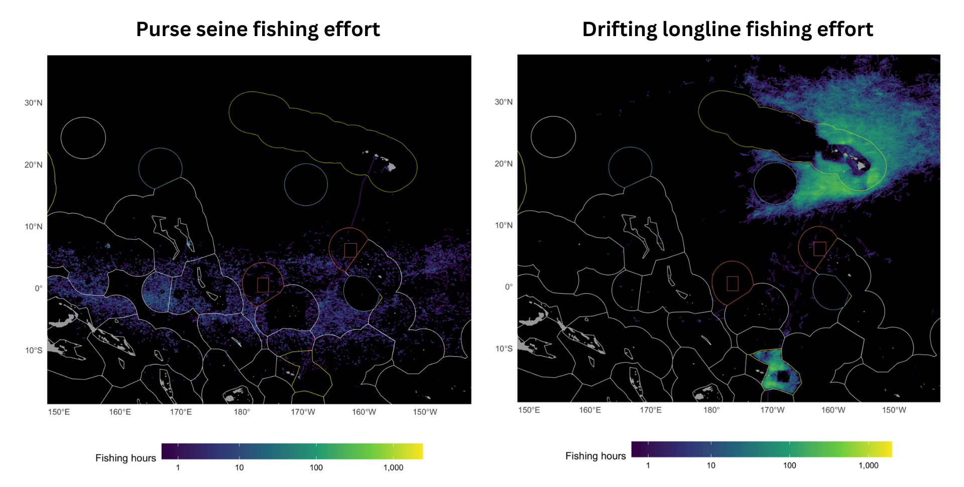
Fishing effort (hours) for purse seine (left) and drifting longlines (right) in and around the proposed Sanctuary, aggregated across U.S. flagged vessels and most recent 5 years (2018-2022). The current PRI Monument area is shown as a blue outline, the additional proposed Sanctuary protections are shown as a red outline, the U.S. EEZ is shown as a yellow outline, and all other EEZs are shown as white outlines.
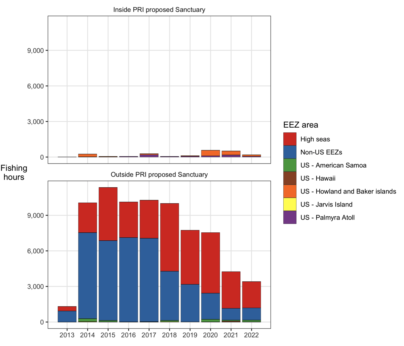
Purse seine fishing effort (hours) between 2013 and 2022 for trips that landed in Pago Pago, by the U.S.-flagged fleet, and looking across all EEZs and the high seas (non-U.S. EEZs are grouped together as ‘Non-U.S. EEZs’). The top panel shows trends for areas inside the proposed Sanctuary, the bottom panel shows trends for areas outside the proposed Sanctuary. The fill of the bars represents either different U.S. EEZ areas, the high seas, or non-U.S. EEZs.
So where does U.S. fishing effort occur in the Pacific? When narrowing in on U.S. fishing trips that landed in Pago Pago between 2018 and 2022, we find that the majority of U.S. purse seine fishing effort happens in the high seas (60.24%) or within non-US EEZs (33.54%), and most U.S. drifting longline fishing trips landing in Pago Pago occur within the American Samoa EEZ area (98.28%). In fact, U.S. purse seine and longline vessels spent only 4.16% and 0.00% (respectively) of their total Pacific fishing effort within the expansion area for trips landed in Pago Pago.
As NOAA’s Office of National Marine Sanctuaries considers the designation of a new Sanctuary to protect the Pacific Remote Islands, it is critical to understand how U.S. flagged purse seine and longline vessels have historically used this proposed protected area for fishing. Details from our report have been submitted to the U.S. National Oceanic and Atmospheric Administration’s Office of National Marine Sanctuaries to inform their efforts scoping a National Marine Sanctuary to protect the Pacific Remote Islands.
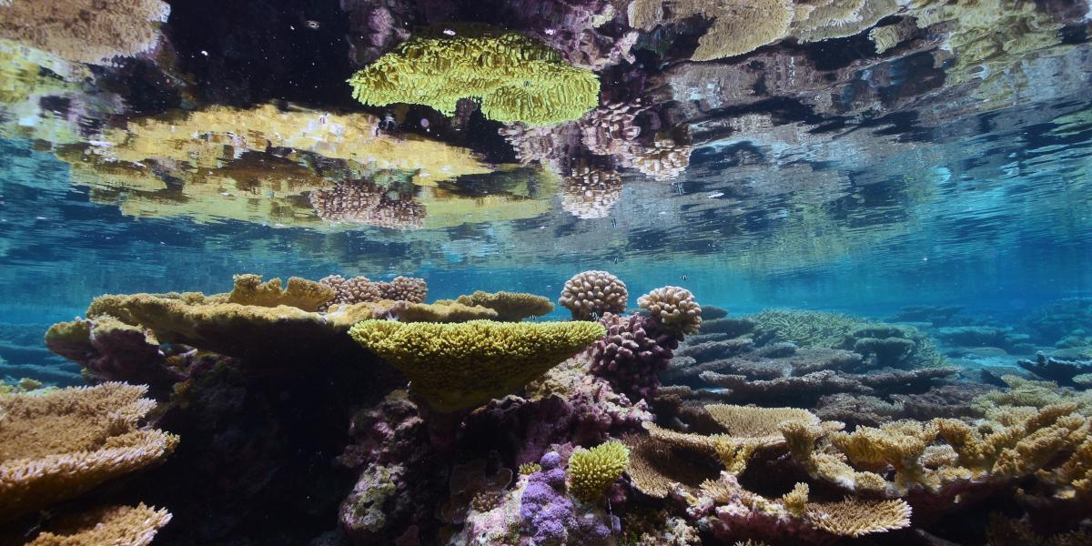
Banner image photo credit: Coral tables Palmyra Atoll - Kydd Pollock, The Nature Conservancy